Introduction
NCERT Notes for Class 10 Social Science (Geography) Chapter 1 – Resources and Development
Class 10 Geography Chapter 1 exposes you to resources and their categorization. Additionally, through delving into the chapter’s details, you will learn about India’s resource development and resource planning. You will get knowledge about India’s land resources and the categorization of the many kinds of soils present in the country. The chapter concludes with a discussion on Soil Erosion and Conservation. All of these subjects are thoroughly explored in “CBSE Notes Class 10 Geography Chapter 1 – Resources and Development.” Examine these CBSE Class 10 Social Science notes to improve your study skills.
CBSE Class 10 Social Science notes will assist students in studying the topic thoroughly and clearly.
TYPES OF RESOURCES
- Biotic and abiotic resources (-) depending on their origin.
- On the basis of resources which have a particular limit and exhaustibility (-) renewable and non-renewable resources are the two types which come into place.
- Individual resources, Community-owned resources, National resources, and International resources are the four types of resources regarding private ownership.
- There are four general types of resources based on their stage of development: potential resources, developed resources, stock and reserves.
DEVELOPMENT OF RESOURCES
- We all are quite aware that humans use resources unfairly, and it has resulted in major issues such as resource depletion to satisfy the greed of a few individuals; resource concentration in a few hands; and uncontrolled resource exploitation, that has resulted in global ecological crises such as global warming, ozone layer depletion, and so on.
- For the long-term survival of all forms of life and maintaining global peace, a fair allocation of resources is necessary.
- The Rio Convention recognised global forest principles and adopted Agenda 21 for the twenty-first century’s environmental sustainability.
RESOURCE PLANNING
- Mineral and coal resources exist in the states of Jharkhand, Chhattisgarh, and Madhya Pradesh. Water resources exist in Arunachal Pradesh, but infrastructure development is lacking.
- Rajasthan has abundant solar and wind energy, but it needs water resources. Ladakh has a rich cultural past, yet it lacks water, infrastructure, and certain essential minerals.
RESOURCE PLANNING IN INDIA
Resource planning is a three-step procedure that includes the following:
- Surveying, mapping, and qualitative and quantitative evaluation and measurement of resources are all part of the process of identifying and recording resources.
- Creating a planning system that includes the appropriate technology, skills, and institutional set-up for putting resource development plans into action.
- Examining resource development plans in comparison to national development plans.
CONSERVATION OF RESOURCES
- Any developmental activity requires resources. Its protection at many levels is crucial for resolving socio-economic and environmental issues.
- Gandhian philosophy is presented in Schumacher’s film Small is Beautiful (1974).
- The Brundtland Committee’s Report (1987), reported in the book Our Common Future, developed the concept of “sustainable development” and asserted it as a means of resource conservation.
LAND RESOURCES
LAND UTILISATION
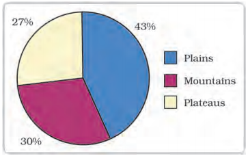
India’s land area is divided into three sections: plains, which provide facilities for agriculture and industry, mountains, which ensure the perpetual flow of some rivers and provide tourism and ecological benefits, and plateaus, which contain rich supplies of minerals, fossil fuels, and forests.
Forests, non-cultivable land, other uncultivated land, fallow lands, and net sown area are all examples of land resources.
LAND USE PATTERN IN INDIA
- Land usage is influenced by both physical and human causes.
- India’s total geographical area is 3.28 million square kilometres. The country’s forest area is significantly less than the intended 33 percent of total land area (source : National Forest Policy, 1952)
- India has around 130 million hectares of degraded land (of which 28 percent forest degraded area, 56 percent water eroded area and 16 percent saline and alkaline deposits)
LAND DEGRADATION AND CONSERVATION MEASURES
Land degradation has been worsened by human activities such as deforestation, overgrazing, and mining. Afforestation, effective grazing management, planting of plant shelter belts, and control of overgrazing, among other things, can assist to decrease land degradation.
SOIL AS A RESOURCE
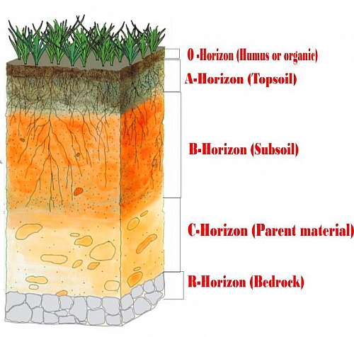
- The most valuable renewable natural resource is soil. It is a significant living system that serves as a medium for plant growth and supports various forms of living species on the planet.
- Soil formation up to a depth of a few centimetres takes millions of years.
- Relief, parent rock or bed rock, climate, vegetation, and other types of life, as well as time, all contribute to the creation of soil.
- Various natural forces, such as temperature changes, running water’s operations, and so on, all contribute to the creation of soil.
CLASSIFICATION OF SOILS
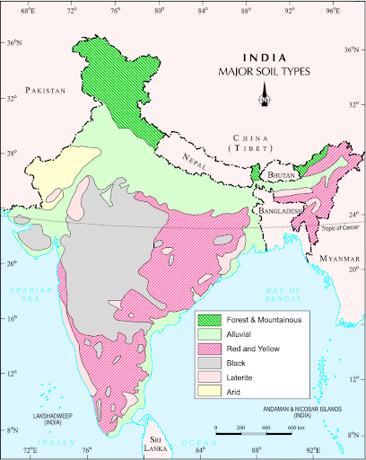
- Soil can be categorized according to the characteristics that contribute to its development, such as colour, thickness, texture, age, chemical, and physical properties. Alluvial soil, Black soil, Red and Yellow soils, Laterite soil, Arid soil, and Forest soil are examples of different types of soil.
- The Indus, Ganga, and Brahmaputra are three major Himalayan river systems that deposit alluvial soils. It can be found in the Mahanadi, Godavari, Krishna, and Kaveri rivers’ deltas. Alluvial soils are categorised as Bangar (old alluvial) or Khadar (new alluvial) based on their age.
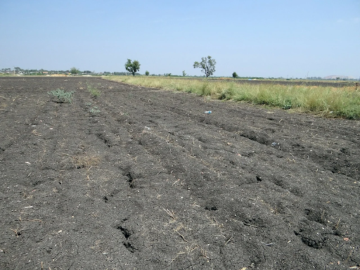
- Black dirt, commonly known as black cotton soil, is great for growing cotton.
- Red soils have a reddish colour due to iron absorption in crystalline and metamorphic rocks. When it is hydrated, it has a yellow appearance.
- Laterite soil is the product of extensive rain-induced leaching. It may be cultivated with the right amount of manure and fertiliser.
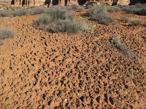
- Arid soils have a sandy texture and are saline. Evaporation occurs faster due to the dry climate and high temperatures, and the soil lacks humus and moisture.
- Forest soils in valley sides are loamy and silty, whereas upper slopes have finer grain. In the Himalayan snow-covered areas, these soils are acidic and humus-rich.
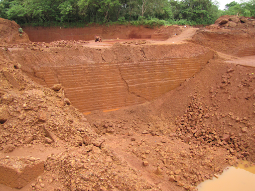
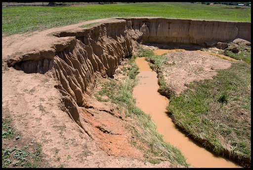
SOIL EROSION AND SOIL CONSERVATION
- Soil erosion is the loss of top fertile soil cover owing to a variety of natural factors such as wind, glaciers, and water. Soil development and erosion occur at the same time, and there is usually a balance between the two. However, human activities can occasionally disrupt this balance. Defective farming methods also contribute to soil erosion.
- Contour ploughing, terrace cultivation, and shelterbelts are examples of soil erosion prevention techniques.
Outro
NCERT Solved Question Answer CBSE Class 10 Geography Chapter 01 – Resources and Development
Question 1.
(a) What type of resource is iron ore?
(b) Which is a replenishable type of resource?
(c) State one cause of land degradation in Punjab.
(d) In which state is terrace cultivation practised?
(e) Mention one state where black soil is found.
Answer:
(a) Non-renewable.
(b) Tidal energy.
(c) Intensive cultivation.
(d) Uttarakhand.
(e) Gujarat.
Question 2.
Answer the following questions in about 30 words :
- Name three states having black soil and the crop which is mainly grown in it.
- What type of soil is found in the river deltas of the eastern coast? Give three main features of this type of soil.
- What steps can be taken to control soil erosion in the hilly areas?
- What are the biotic and abiotic resources? Give some examples.
Answer:
- The states of Maharashtra, Madhya Pradesh, and Chhattisgarh have dark soil. The main crop grown in this soil is cotton. This soil is also called “Regur” and “black cotton soil.”
- The river deltas on the eastern coast have alluvial soil.
- Alluvial soil contains different amounts of sand, silt, and clay.
- The main parts of alluvial soil are:
- These soils are very fertile and good for farming because of this.
- They have the right amounts of potash, phosphoric acid, and lime for growing sugarcane, paddy, and other crops.
- In drier places, these soils are more alkaline.
- In hilly areas, soil erosion can be stopped by contour ploughing, which is ploughing along the slopes, using terrace farming techniques, and using strips of grass to stop wind and water from washing away the soil.
- Biotic Resources: The resources that come from the biosphere and have life are called Biotic Resources. Examples of biotic resources are animals, plants, humans, fish, livestock, etc.
- Abiotic Resources are resources that are made up of non-living things.
- Some examples of abiotic resources are water, minerals, metals, wind, solar energy, etc.
Question 3(1).
Answer the following questions in about 120 words :
(1) Explain land use pattern in India and why has the land under forest not increased much since 1960-61.
Answer:
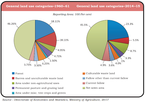
(1) The land use for different purposes in the year 1960-61 and 2002-03 is as given B below:
- Based on the above chart and other facts that are known, the main features of India’s land use pattern are as follows:
- The total land area of India is 3.28 million square kilometres.
- Land use data, on the other hand, is only available for 93 percent of the total area because land use reporting for most of the north-east states except Assam has not been done fully. Some parts of Jammu and Kashmir that are occupied by Pakistan and China have also not been surveyed.
- The amount of land used for permanent pasture has decreased.
- The pattern of the net-sown area varies a lot from one state to another. It is more than 80 percent of the total area in Punjab and Haryana, but less than 10 percent in Arunachal Pradesh, Mizoram, Manipur, and the Andaman and Nicobar Islands.
- The amount of land covered by forests has changed slightly, from 18.1% in 1960-1961 to 22.57% in 2002-2003. It is still a lot less than the 33 percent of the land area that was hoped for in the National Forest Policy (1952). The amount of forest land hasn’t grown because of things like the spread of agriculture, large-scale development projects or river valley projects, grazing, and fuel collection.
- Some of the land is called “wasteland” and is used for things other than agriculture.
Question 3(2).
How has technical and economic development led to more consumption of resources?
Answer: Technical and economic development has led to more consumption of resources due to reasons as mentioned below :
- As the level of technological development goes up, more and more resources are needed for production.
- Gandhiji said that the exploitative nature of modern technology is the main reason why the world’s resources are running out.
- Most of the time, it was the higher level of technological development in the countries that did the colonising that helped them take advantage of the resources of other areas and establish their dominance over the colonies. So, resources can only help with development if they are paired with the right technological development and institutional changes. India has been through all of these things at different times during colonisation.
- So, it is true that technical and economic progress leads to more use of resources. Water resources are being used to expand irrigated areas and dry-season agriculture. As a result, as in Punjab and Haryana, the water level has gone down, causing problems for the farmers.
Question 4.
Imagine if oil supplies get exhausted, how will this affect our lifestyle?
Answer:
- If oil supplies run out, the world would stop. People would end up living wherever they are. There will be no more planes, trains, or boats that run.
- For a limited time, prices for any kind of transportation would be so high that only the richest people could afford them.
- We would only be able to use what we already have, like coal, natural gas, etc.
- There would be a lot of job loss because many factories, restaurants, etc. would close.
- Many people would leave cities to live in rural areas.
- Cities would become empty places. There may be killed in order to get control of the things that are needed for survival in the world. We would not only lose our way of life, but also lose touch with the whole world. But scientists are doing research to find other sources of energy, and it is hoped that they will be successful in their efforts. They might be able to use solar or wind energy instead of oil. In that case, if oil supplies run out, it wouldn’t change anything for us. Perhaps things would get better in the future.
Question 5.
Solve the puzzle by following your search horizontally and vertically to find the hidden answers.
- Natural endowments in the form of land, water, vegetation and minerals.
- A type of non-renewable resource.
- Soil with high water retaining capacity.
- Intensively leached soils of the monsoon climate.
- Plantation of trees on a large scare to check soil erosion.
- The Great Plains of India are made up of these soils.
Answer:
- Resource
- Minerals
- Laterite
- Black
- Afforestation
- Alluvial.