Here you will find exam notes for CBSE NCERT Class 11 Geography Notes for Chapter 3: Interior of the Earth
Sources of Information about the Interior of the Earth
As the earth’s diameter is about 6,370 km, its interior is very deep and cannot be directly accessed. Most knowledge about the interior is based on scientific guesses and inferences. However, some information also comes from directly observing and analysing materials originating from the interior.
Short Pointers for Revision:
- Earth’s interior cannot be directly accessed or sampled due to great depth
- Knowledge mainly based on guesses and inferences by scientists
- Some information from analysis of originating materials
The discovery that the earth has a solid inner core came when scientists analysed earthquake waves that had travelled through the earth. The waves move slower through the inner core compared to the outer core, indicating the inner core is solid due to immense pressure. This provided insights about conditions deep in the earth’s interior.
The two most important sources about the interior of the earth are:
- Direct sources
- Indirect sources
Direct Sources
Direct sources provide firsthand information about the Earth’s interior through:
- Mining: Surface rocks from mining, like those in South Africa’s gold mines, offer insights into the upper layers of the Earth.
- Drilling: To surpass the 3–4 km depth limitation of mines due to extreme heat, projects like the Deep Ocean Drilling Project and Integrated Ocean Drilling Project have been initiated. The Kola Peninsula’s 12 km deep drill exemplifies this effort, yielding valuable data from different crustal depths.
- Volcanic Eruptions: Magma expelled during eruptions, upon reaching the surface, can be analysed in labs. However, pinpointing the exact depth of the magma’s origin remains challenging.
Indirect Sources
Indirect sources infer information about the Earth’s interior through various means:
- Meteors: Studying meteors, composed similarly to Earth, provides indirect knowledge about the Earth’s composition.
- Gravitation: Variations in gravitational force across the Earth’s surface, stronger near the poles and weaker at the equator, along with the effect of the mass distribution of Earth’s materials, aid in understanding the interior structure.
- Magnetic Field: Magnetic surveys reveal the distribution of magnetic materials in the crustal part, offering insights into the subsurface composition.
- Seismic Activity: This is a crucial method for exploring the Earth’s interior. Seismic waves provide a comprehensive view of the Earth’s internal layering.
The Kola Superdeep Borehole
Located in the Kola Peninsula, Russia, this borehole is one of the deepest man-made holes, reaching over 12 km. It provided unprecedented insights into the Earth’s crust, revealing unexpected geological anomalies and increasing our understanding of seismic activity. This project exemplifies how drilling can extend our knowledge of the Earth’s interior beyond the limitations of mining and volcanic studies.
Quick Revision Points
- Mining and drilling are key direct sources for studying Earth’s interior.
- Volcanic eruptions offer surface-accessible material for analysis.
- Meteor study, gravitational variation, magnetic surveys, and seismic activity are vital indirect sources.
- The Earth’s composition and structure are inferred from these sources.
Earthquakes
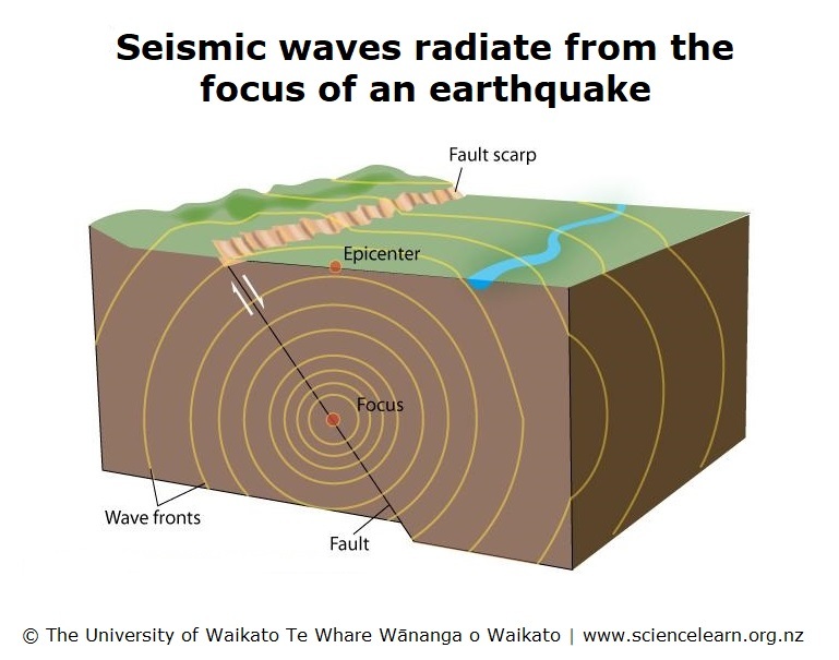
An earthquake is a natural phenomenon characterised by the shaking of the earth. It occurs when energy stored along faults in the Earth’s crust is suddenly released. This release of energy generates seismic waves that travel in all directions.
The point within the Earth where this energy release originates is called the hypocenter or focus, while the point directly above it on the Earth’s surface is known as the epicentre. The primary cause of an earthquake is the movement of rocks along a fault, overcoming the friction holding them together, leading to a sudden shift and the release of energy.
Example:
The 2011 Tōhoku Earthquake in Japan is a significant example. It was a powerful undersea earthquake that occurred on March 11, 2011, off the Pacific coast of Tōhoku. This earthquake caused a massive release of energy along a fault line, leading to strong ground shaking and a devastating tsunami. The Tōhoku Earthquake’s focus was undersea, and the waves of energy it released were felt strongly at the nearest coastal epicentre. This event illustrates how an earthquake originates and its potential impacts.
Short Pointers for Revision:
- Earthquakes are caused by the sudden release of energy along faults.
- Seismic waves radiate in all directions from the earthquake’s focus.
- The hypocenter (or focus) is the point of energy release within the Earth.
- The epicentre is directly above the focus on the Earth’s surface.
- Earthquakes occur due to the overcoming of friction between rocks along a fault.
- The Tōhoku Earthquake is an example of a significant seismic event with notable consequences.
Earthquake Waves
Earthquake waves are seismic waves generated by earthquakes that occur within the lithosphere, up to a depth of 200 km from the Earth’s surface. These waves are recorded by an instrument called a seismograph. There are two main types of earthquake waves: Body waves and Surface waves. Body waves travel through the Earth’s interior, while Surface waves propagate along the Earth’s surface.
Example:
The 1994 Northridge earthquake in California provides a practical example. This earthquake produced strong seismic waves that were recorded by numerous seismographs. The analysis of these waves helped in understanding the earthquake’s mechanism and its effects on the Earth’s surface, demonstrating the distinct characteristics and impacts of both Body and Surface waves.
Short Pointers for Revision:
- Earthquake waves occur within the lithosphere (up to 200 km deep).
- Seismographs record these waves.
- There are two types of earthquake waves: Body waves and Surface waves.
- Body waves travel through the Earth’s interior.
- Surface waves move along the Earth’s surface.
- The 1994 Northridge earthquake is an example of the effects of earthquake waves.
Earthquake waves are basically of two types
- Body waves and
- Surface waves
Body Waves in Earthquakes
Body Waves are types of seismic waves generated at the focus of an earthquake and propagate through the Earth’s interior. There are two types of body waves: P-waves (Primary waves) and S-waves (Secondary waves).
P-waves, the faster of the two, travel quickly and can move through gases, liquids, and solids, similar to sound waves. S-waves, on the other hand, are slower and can only travel through solids. The behaviour of S-waves is crucial in helping scientists understand the Earth’s internal structure.
Short Pointers for Revision:
- Body Waves are generated at the earthquake’s focus and travel through the Earth’s interior.
- There are two types of body waves: P-waves (Primary waves) and S-waves (Secondary waves).
- P-waves travel faster and can move through gases, liquids, and solids.
- S-waves are slower and can only travel through solids.
- The behaviour of S-waves helps scientists understand the Earth’s internal structure.
- The 1964 Alaska Earthquake is an example of the practical study of P-waves and S-waves.
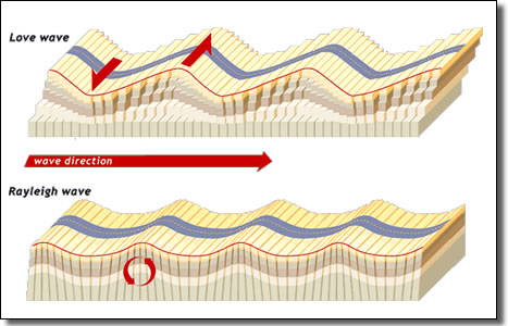
Surface Waves in Earthquakes
Surface Waves are seismic waves that are generated when body waves reach the Earth’s surface and interact with surface rocks. These waves cause the ground to move. Their speed varies depending on the density of the material they pass through, moving faster through denser materials. Additionally, surface waves change direction when encountering materials of different densities.
They are recorded last on a seismograph and are known for being the most destructive type of seismic waves, as they can cause significant movement of rocks and damage to structures.
Example: The 2010 Haiti Earthquake serves as a notable example. In this earthquake, surface waves caused extensive damage to buildings and infrastructure. The variation in wave speed and direction due to different ground materials contributed to the uneven distribution of damage across the affected area. This event highlights the destructive nature of surface waves and their impact on the Earth’s surface.
Short Pointers for Revision:
- Surface Waves are created when body waves reach and interact with the Earth’s surface.
- These waves cause the ground to move.
- Their speed changes with the density of the material they travel through, being faster in denser materials.
- Surface waves change direction upon encountering materials of different densities.
- They are recorded last on a seismograph.
- Surface waves are particularly destructive, capable of moving rocks and damaging structures.
- The 2010 Haiti Earthquake exemplifies the destructive impact of surface waves.
Emergence of Shadow Zones in Seismic Activity

Shadow zones in seismic activity refer to areas on the Earth’s surface where seismic waves (P and S waves) from an earthquake are not detected. Seismographs within 105° of an earthquake’s center record both P and S waves. However, beyond 105°, only P-waves are recorded and S-waves are absent.
The shadow zone for both P and S waves is identified between 105° and 145° from the earthquake’s center. The P-wave shadow zone forms a band encircling the Earth in this range. In contrast, the S-wave shadow zone is more extensive, covering over 40% of the Earth’s surface, as S-waves do not reach areas beyond 105° from the earthquake’s center.
Example: The 2004 Indian Ocean Earthquake is a pertinent example. This massive undersea earthquake led to the creation of significant shadow zones. The analysis of these zones provided crucial insights into the Earth’s internal structure and the behaviour of seismic waves, particularly the absence of S-waves in certain regions and the presence of P-waves in others.
Short Pointers for Revision:
- Shadow zones are areas where seismic waves from an earthquake are not detected.
- Seismographs within 105° of the earthquake’s center record both P and S waves.
- Beyond 105°, only P-waves are detected, creating a shadow zone for S-waves.
- The shadow zone for P and S waves ranges between 105° and 145° from the earthquake’s center.
- The P-wave shadow zone forms a band around the Earth in this range.
- The S-wave shadow zone is larger, covering over 40% of the Earth’s surface.
- The 2004 Indian Ocean Earthquake is an example of the formation and analysis of seismic shadow zones.
Types of Earthquakes
There are several types of earthquakes, each with distinct causes:
- Tectonic Earthquakes: The most common type, occurring when rocks slide along a fault plane.
- Volcanic Earthquakes: A subset of tectonic earthquakes, these occur during volcanic eruptions and are found only in areas with active volcanoes.
- Collapse Earthquakes: These happen in mining areas when the roofs of underground mines collapse, causing small tremors.
- Explosion Earthquakes: Caused by the detonation of chemical or nuclear devices.
- Reservoir Induced Earthquakes: Occur near large bodies of water, often associated with the creation of reservoirs.
Example: The 1975 Haicheng Earthquake in China is an example of a tectonic earthquake. This event demonstrated the typical characteristics of tectonic earthquakes, where stress along a fault line led to significant seismic activity. Its study has contributed to understanding the mechanics and effects of tectonic earthquakes.
Short Pointers for Revision:
- Tectonic Earthquakes: Most common, caused by movement along faults.
- Volcanic Earthquakes: Occur during volcanic eruptions, limited to regions with active volcanoes.
- Collapse Earthquakes: Result from the collapse of underground mine structures.
- Explosion Earthquakes: Triggered by large explosions, including nuclear detonations.
- Reservoir Induced Earthquakes: Associated with large bodies of water, especially near reservoirs.
- The 1975 Haicheng Earthquake is a case study for tectonic earthquakes.
Measuring Earthquakes

Earthquakes are measured in terms of magnitude and intensity. The magnitude, which reflects the amount of energy released by an earthquake, is rated on the Richter scale. This scale assigns a numerical value between 0 and 10, with higher numbers indicating more powerful earthquakes.
Intensity, on the other hand, is measured using the Mercalli Intensity Scale, developed by Italian seismologist Giuseppe Mercalli. This scale ranges from 1 to 12 and is based on the observable effects and damage caused by the earthquake, rather than the energy it releases.
Short Pointers for Revision:
- Magnitude: Measured using the Richter scale, indicates the energy released by an earthquake, rated between 0 and 10.
- Intensity: Assessed with the Mercalli Intensity Scale, based on observed damage and effects, ranges from 1 to 12.
- The Richter scale is quantitative, while the Mercalli scale is qualitative, assessing the impact on structures and people.
Example: The 1994 Northridge Earthquake in Los Angeles is a relevant example. It measured 6.7 on the Richter scale, indicating a high release of energy. In terms of intensity, it reached a high level on the Mercalli scale, causing significant structural damage and widespread effects in the affected area. This earthquake exemplifies how both scales are used to assess the severity and impact of seismic events.
Earthquake Effects and Characteristics
An earthquake is a natural hazard characterized by sudden ground movements, resulting in a series of immediate dangers, including ground shaking, differential ground settlement, land and mud slides, soil liquefaction, ground lurching, avalanches, ground displacement, floods from dam and levee failures, fires, structural collapse, falling objects, and tsunamis. Tsunamis are distinct phenomena triggered by undersea earthquakes with high magnitudes.
Real-life Case Study, Example: The 2011 Tōhoku earthquake in Japan is a notable example. On March 11, 2011, a massive undersea earthquake with a magnitude of 9.0 struck off the northeastern coast of Japan. The ground shaking and subsequent tsunami caused widespread devastation, resulting in significant loss of life, destruction of infrastructure, and economic impacts.
Short Pointers for Revision:
- Earthquakes are a natural hazard.
- Immediate dangers of an earthquake include ground shaking, differential ground settlement, land and mudslides, soil liquefaction, ground lurching, avalanches, ground displacement, floods from dam and levee failures, fires, structural collapse, and falling objects.
- Tsunamis are distinct and occur when the earthquake’s epicentre is under the ocean with a high magnitude.
- Example: 2011 Tōhoku earthquake in Japan – magnitude 9.0, significant loss of life and infrastructure damage.
Frequency of Earthquake Occurrences
Earthquake frequency refers to how often earthquakes occur and their potential for damage. High-magnitude earthquakes, with a magnitude of 8 or higher, are infrequent, happening once every one to two years. In contrast, smaller earthquakes occur almost every minute.
Real-life Case Study, Example: The 1906 San Francisco earthquake serves as an example of a high-magnitude earthquake. It had an estimated magnitude of 7.9 and caused significant destruction in San Francisco and neighbouring areas. The frequency of such powerful earthquakes is relatively low.
Short Pointers for Revision:
- Earthquake frequency relates to how often earthquakes happen and their potential impact.
- High-magnitude earthquakes (magnitude 8 or higher) are rare, occurring once every one to two years.
- Smaller earthquakes are much more frequent, happening almost every minute.
- Example: 1906 San Francisco earthquake, magnitude 7.9, caused major damage and serves as an example of a less frequent, high-magnitude earthquake.
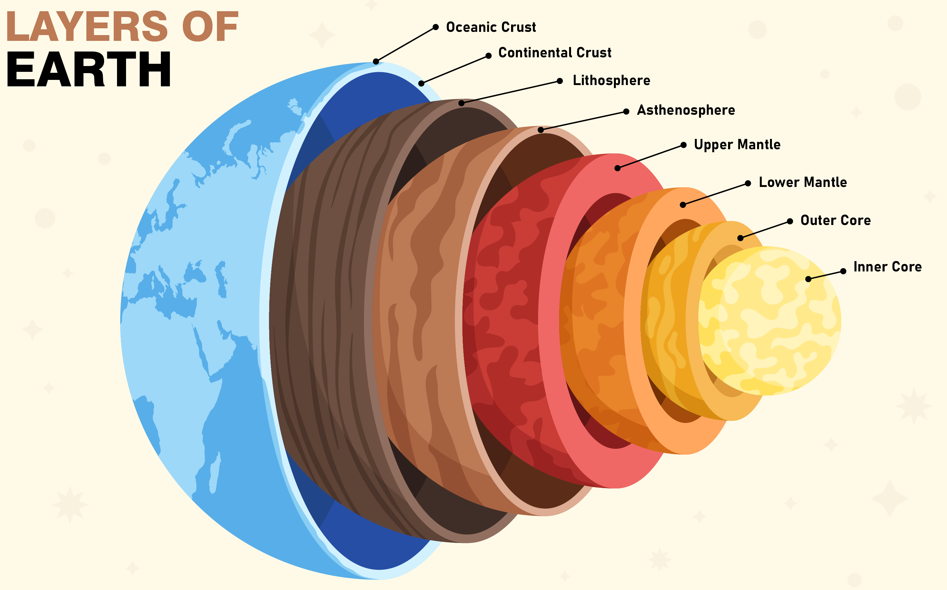
Structure of the Earth
The Earth is composed of three primary layers: the Crust, the Mantle, and the Core.
Crust: The Crust is the solid outer layer that envelops the Earth’s surface. It is not uniformly thick; the continental crust measures approximately 30 km in thickness, while the oceanic crust is much thinner, about 5 km. In regions with towering mountain ranges like the Himalayas, the continental crust can reach depths of up to 70 km.
The continental crust consists mainly of various types of rocks and has a density of approximately 3 g/cm³. In contrast, the oceanic crust is primarily composed of basalt rock and has a lower density of about 2.7 g/cm³.
Mantle: Below the Crust lies the Mantle, extending to a depth of 2,900 km. The upper part of the Mantle, known as the asthenosphere, is approximately 400 km thick and is thought to have a relatively weaker structure. Volcanic magma originates from the asthenosphere, making it a crucial source for volcanic activity. The combination of the Crust and the upper Mantle forms the lithosphere, which ranges from 10 to 200 km in thickness. Beneath the asthenosphere lies the solid lower mantle.
Core: The Core starts at a depth of 2,900 km and is composed of two distinct layers: a solid inner core and a liquid outer core. This region is predominantly composed of nickel and iron, earning it the nickname “nife” layer. The density of the Core varies, with a density of about 5 g/cm³ at the boundary with the Mantle and increasing to approximately 13 g/cm³ in the middle.
Example: As a real-life case study, volcanic activity provides a tangible illustration of the Earth’s structure. Magma rising from the asthenosphere, which is the upper part of the Mantle, leads to the formation of volcanoes. This process underscores the interaction between the Mantle and the Crust, revealing the Earth’s internal structure.
Quick Revision Tips:
- Crust: Varies in thickness, continental (30 km) vs. oceanic (5 km), continental crust denser (3 g/cm³), oceanic crust primarily basalt (2.7 g/cm³).
- Mantle: Extends to 2,900 km, asthenosphere (up to 400 km, source of volcanic magma), lithosphere (upper mantle + crust), solid lower mantle.
- Core: Begins at 2,900 km, solid inner core, liquid outer core, nickel and iron composition, density increases from 5 g/cm³ to 13 g/cm³ toward the center.
- Volcanic Activity Example: Demonstrates how magma from the upper Mantle (asthenosphere) reaches the Earth’s surface.
Volcanoes

A volcano is a geographical formation from which gases, ash, and molten rock, known as lava, are expelled. An “active” volcano is one that has erupted recently or is currently erupting. Volcanoes are connected to the Earth’s mantle, the layer beneath the crust, which is denser than the crust. A key region within the mantle is the asthenosphere, a weaker zone where molten rocks ascend towards the surface.
Magma, the molten rock within the mantle, becomes lava when it reaches or moves close to the Earth’s crust. Eruptions can produce lava flows, pyroclastic debris, volcanic bombs, ash, dust, and gases such as nitrogen and sulfur compounds, alongside trace amounts of chlorine, hydrogen, and argon.
Example: The eruption of Mount St. Helens in 1980 is a classic example. It showcased the powerful release of ash, gas, and lava, dramatically altering the surrounding landscape. This event highlighted the destructive potential of volcanic eruptions and the various materials expelled, including pyroclastic debris and volcanic gases.
Short Pointers for Revision:
- Definition: A volcano is a natural outlet for lava, gas, and ash.
- Active Volcanoes: Those that have erupted recently or are currently erupting.
- Mantle and Asthenosphere: Mantle is denser than crust; asthenosphere in mantle is where molten rocks rise.
- Magma and Lava: Magma is molten rock in mantle, becomes lava near surface.
- Eruption Products: Lava flows, pyroclastic debris, volcanic bombs, ash, dust, gases (nitrogen/sulphur compounds, chlorine, hydrogen, argon).
Types of Volcanoes

Volcanoes are categorised based on their eruption style and surface appearance into several types:
- Shield Volcanoes: These are large, with gentle slopes, primarily made of basalt, a lava that flows easily. An example is the Hawaiian volcanoes. They rarely explode unless water enters the vent, forming a cinder cone at the top.
- Composite Volcanoes: These volcanoes eject cooler and stickier lavas than basalt and are known for their explosive eruptions. They accumulate pyroclastic materials and ashes along with lava, creating layers around the vent and resembling a group of volcanoes.
- Calderas: These are extremely explosive, often collapsing on themselves during eruptions, forming large craters. Their explosiveness indicates a large and nearby magma chamber.
- Flood Basalt Provinces: Characterised by highly fluid lava that covers large areas, sometimes over thousands of square kilometres. These flows can be over 50m thick and stretch for hundreds of kilometres. An example is the Deccan Traps in India.
- Mid-Ocean Ridge Volcanoes: Located along the ocean ridges, these underwater volcanoes form a system over 70,000 km long and are known for frequent eruptions.
Example: The Hawaiian volcanoes are a prime example of Shield Volcanoes. Their eruptions are typically characterised by flowing basalt lava, forming the distinctive gentle slopes of these volcanoes.
Short Pointers for Revision:
- Shield Volcanoes: Large, gentle slopes, basalt lava, rare explosions, e.g., Hawaiian volcanoes.
- Composite Volcanoes: Explosive, cooler, stickier lava, accumulates pyroclastic materials and ashes.
- Calderas: Extremely explosive, collapse to form craters, indicate large, nearby magma chambers.
- Flood Basalt Provinces: Fluid lava covering vast areas, e.g., Deccan Traps in India.
- Mid-Ocean Ridge Volcanoes: Underwater, along ocean ridges, frequent eruptions, extensive system.
Volcanic Landforms
Volcanic landforms are the various shapes and features of the Earth’s surface created by volcanic activity and eruptions. These landforms result from the accumulation and arrangement of materials expelled during volcanic events, such as lava, ash, and volcanic rocks.
Example: A prominent example is the Hawaiian Islands, formed by volcanic activity. These islands are shaped by the accumulation of lava flows from numerous volcanic eruptions over time, showcasing the formation of volcanic landforms.
Short Pointers for Revision:
- Volcanic Landforms: Earth’s surface shapes created by volcanic activity.
- Formation: Result from lava, ash, and volcanic rock accumulation during eruptions.
- Example: Hawaiian Islands, shaped by accumulated lava flows from volcanic eruptions.
Intrusive Igneous Rock Forms
:max_bytes(150000):strip_icc()/about-igneous-rocks-1438950_final_CORRECTED2FINAL-f8d738e151b9437caa256d21155d091f.png)
Intrusive forms are various shapes formed by magma that cools and solidifies beneath the Earth’s surface, becoming igneous rocks. These forms include:
- Batholiths: Large, dome-shaped masses of igneous rock, typically granite, formed from cooled magma deep within the Earth. They become visible only after the overlying material is eroded away.
- Lacoliths: Dome-shaped, large intrusions with a flat base, connected to magma sources below by pipe-like structures. They are similar to volcanic domes but are located deeper underground.
- Lapoliths: Saucer or plate-shaped structures, curving upwards, formed by upward and lateral movement of magma.
- Phacoliths: Wavy structures found in folded rock layers, typically near the tops of anticlines or bottoms of synclines, linked to deeper magma chambers.
- Sills and Sheets: Horizontal or nearly horizontal bodies of igneous rock; thinner formations are called sheets, while thicker, flat ones are known as sills.
- Dykes: Wall-like formations created when magma solidifies in cracks and fissures within the Earth’s crust.
Example: An example of intrusive forms can be found in the Karnataka plateau, India, where domal hills of granite rocks are visible. These are likely laccoliths and batholiths, providing a clear example of these formations. Additionally, dykes in western Maharashtra are associated with the Deccan Traps, showcasing how these structures feed volcanic eruptions.
Short Pointers for Revision:
- Intrusive forms are underground igneous rock shapes.
- Batholiths: Large, granite, dome-shaped, visible after erosion.
- Lacoliths: Dome-shaped, large, with flat bases, deep underground.
- Lapoliths: Saucer or plate-shaped, curves upwards.
- Phacoliths: Wavy structures in folded rock layers.
- Sills and Sheets: Horizontal igneous rock bodies, thickness varies.
- Dykes: Wall-like structures in crustal cracks, linked to eruptions.
Example: Granite hills in Karnataka (laccoliths, batholiths) and dykes in Maharashtra (Deccan Traps).